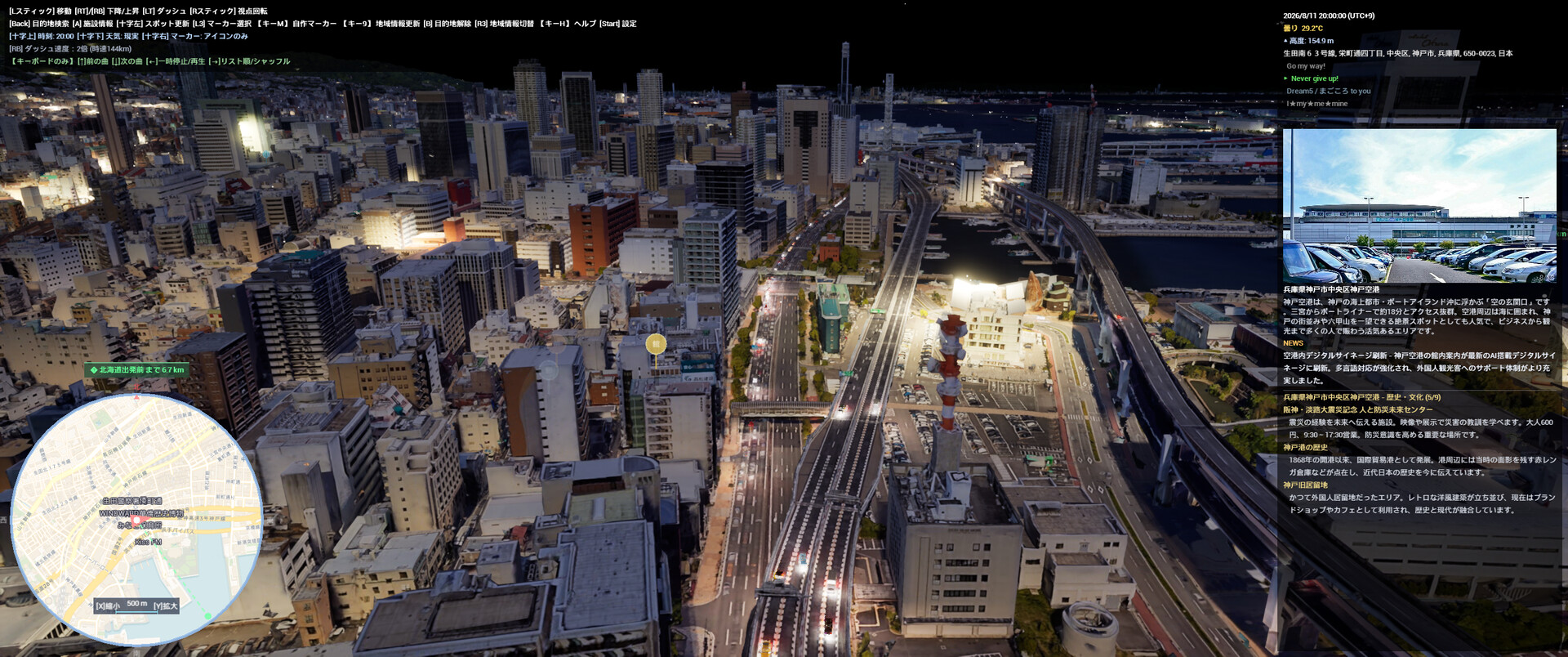

CityExplorer is a drone simulator to explore 3D cities built with PLATEAU, Cesium, and Google Tiles. It features live weather, day/night cycles, AI info panels, and POI markers, making it perfect for virtual tourism and travel planning.

Sign in to add this item to your wishlist, follow it, or mark it as ignored

This game is not yet available on Steam

Coming soon

Interested?
Add to your wishlist and get notified when it becomes available.
 

About This Game

CityExplorer is a simulator that allows you to freely explore photorealistic 3D urban spaces—recreated using PLATEAU, Cesium OSM, and Google 3D Tiles—from a drone's-eye view. Featuring a real-time day/night and weather system reflecting actual weather data and sun positions, AI-guided regional information panels, and POI (Point of Interest) markers for restaurants, tourist spots, and public facilities, this tool can be used for everything from pre-travel research to virtual sightseeing.

CityExplorer - Gameplay & Practical Use Guide

From virtual exploration to practical utility, there are many ways to enjoy CityExplorer.

Chapter 1: Gameplay & Entertainment

1-1. Virtual Travel & Sightseeing

CityExplorer is the ultimate virtual travel tool, allowing you to fly over and explore cities around the world from the comfort of your home.

  • Instant Teleportation: Simply enter the name of a city or tourist spot in the search bar to travel there instantly.

  • Real-Time Weather & Time Cycles: Experience the actual "now" of any location with real-time weather and day/night cycles.

  • AI Loading Screen Guide: The AI automatically provides information on local specialties, tourist attractions, and festivals during loading screens.

  • Night View Mode: Enjoy the mesmerizing and magical nightscapes of global cities.

  • Rain Mode: Experience the unique atmosphere of cities in the rain.

1-2. Photo Mode & Creative Composition

Find beautiful scenery, take screenshots, and build your own collection.

  • Full Environment Control: Freely adjust the time of day and weather to create the perfect scene.

  • Realistic 3D Visuals: Immerse yourself in highly detailed 3D imagery of global cities.

  • Vibrant Nightscapes: Commercial districts illuminated by neon lights at night are highly recommended shooting spots.

  • Custom Markers: Adjust your altitude to find the perfect angle, and save your favorite locations using custom markers.

1-3. Hidden Mode

By entering specific commands, you might unlock a completely different way to enjoy the simulator...!

Chapter 2: Practical Applications

2-1. Pre-Travel & Sightseeing Research

The perfect tool for scouting and planning your next real-world trip.

  • 3D Layout Preview: Check the streetscapes, terrain, and scale of your destination in full 3D beforehand.

  • POI Markers: Easily locate restaurants, tourist attractions, and public facilities.

  • Detailed Info (Spacebar): Access official websites and photos for specific locations.

  • Favorites List: Create and manage a customized "places to visit" wishlist.

  • AI Insights: Learn about regional specialties and festivals ahead of time through the loading screen AI.

2-2. Geography & Educational Use

An excellent educational tool for studying geography and urban development.

  • 3D Topography: Gain a three-dimensional understanding of the terrain and geographical features of cities worldwide.

  • Diverse Landscapes: Learn experientially by exploring varied terrains such as mountainous areas, coastlines, and plains.

  • Cultural Integration: Study geography and culture simultaneously using Wikipedia data and AI-generated information for each region.

  • Real-Time Data Display: Understand geographical relationships with real-time displays of altitude, address, and latitude/longitude.

2-3. Location Scouting for Photography & Videography

A powerful tool tailored for photographers, filmmakers, and video creators.

  • Lighting Simulation: Check lighting conditions at your shooting spot by changing the time of day (Morning, Noon, Evening, Night).

  • Weather Simulation: Simulate environments under sunny, cloudy, or rainy conditions.

  • Composition Testing: Virtually test framing and compositions for aerial and drone photography.

  • Location Management: Automatically generate markers from geotagged photos to manage your shooting locations.

2-4. Real Estate & Neighborhood Research

  • Aerial Inspection: Check the neighborhood atmosphere and surrounding environment of areas you are interested in from above.

  • Surrounding Amenities: Get a comprehensive overview of nearby POIs such as stations, commercial facilities, and parks.

  • Compare Areas: Add multiple locations to your favorites to compare them easily.

2-5. Game Development & 3DCG Reference Material

  • Urban Modeling Reference: Observe 3D cities as reference material for urban modeling.

  • Urban Layouts: Gain a bird's-eye view of building density, road patterns, and green space distribution.

  • Lighting Reference: Utilize the dynamic light source shifts of the day/night and weather systems as lighting references.

Disclaimer: Users are personally responsible for the usage fees and operation of external APIs. The developer cannot guarantee these services, but please refer to the information below:

  • Google Maps API: Credit card registration is required to use the Google Maps API, but with normal usage frequencies, it is highly likely to remain within the free tier.

  • Other APIs: Some APIs other than Google Maps require account registration or have usage limits, but they are currently completely free (no payment method registration required).

  • Developer Setup: By utilizing the Google Maps API for 3D tiles/searches and YOLP for marker displays, the developer remained entirely within the free tiers—including all debug usage (no API usage fees were incurred).

  • Monitoring Feature: As an auxiliary feature, a system to count, monitor, and control the number of requests is included for your reference. (Please note that this does not guarantee accurate counting or usage within the free tier.)

  • Terms of Service: Users are requested to personally check and understand the latest pricing models and terms of service for each API.

AI Generated Content Disclosure

The developers describe how their game uses AI Generated Content like this:

During gameplay, the AI generates regional information and sightseeing guides (utilizing the Google Gemini API / GitHub Models). These generated texts change in real time and may occasionally contain inaccurate information.

Additionally, some images displayed within the game and on the store page utilize assets pre-generated by Google Gemini. (These are pre-generated contents, not live-generated during gameplay.)

Mature Content Description

The developers describe the content like this:

Please note that certain game modes contain mild violence, such as combat. The standard exploration gameplay features absolutely no extreme or mature content.

System Requirements

    Minimum:
    • Requires a 64-bit processor and operating system
    • OS: Windows 10 64-bit
    • Processor: Core i7-8700 / Ryzen 5 3600
    • Memory: 16 GB RAM
    • Graphics: GTX 1070 / RX 5700 (VRAM 8 GB)
    • DirectX: Version 12
    • Storage: 20 GB available space
    • Additional Notes: Internet connection required. Setting up API keys (e.g. Google Maps API) may be necessary.
    Recommended:
    • Requires a 64-bit processor and operating system
    • OS:
    • Processor:
    • Memory: 32 GB RAM
    • Graphics:
    • DirectX: Version 12
    • Storage: 20 GB available space
    • Additional Notes:
There are no reviews for this product

You can write your own review for this product to share your experience with the community. Use the area above the purchase buttons on this page to write your review.

Review Filters